


Geographic Information System
Descrição de Geographic Information System
O aplicativo é um manual completo e gratuito do Geo Informatics System que abrange todos os tópicos importantes com notas detalhadas, diagramas, equações, fórmulas e material do curso.
Este aplicativo tem 100 tópicos com notas detalhadas, diagramas, equações, fórmulas e material do curso, os tópicos estão listados em 5 capítulos. O aplicativo é obrigatório para todos os estudantes de ciências da engenharia
Baixe o aplicativo como material de referência e livro digital para programas de engenharia civil e outros e cursos de graduação.
O App foi desenvolvido para aprendizado rápido, revisões, referências na hora de exames e entrevistas.
Este aplicativo cobre a maioria dos tópicos relacionados e explicações detalhadas com todos os tópicos básicos.
Alguns dos tópicos abordados neste aplicativo do Sistema de Informações Geográficas são:
1. INTRODUÇÃO DO SIG
2. SIG para Geocomputação
3. Facilitação Tecnológica
4. FUNCIONALIDADE BÁSICA DO SIG
5. UMA DEFINIÇÃO DE SISTEMA DE SIG
6. Ciência GIS e a Ascensão da Engenharia de Geoinformação
7. CIÊNCIA GIS A SEGUIR
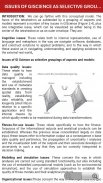
8. QUESTÕES DE GISCIÊNCIA COMO GRUPO SELETIVO DE ASPECTOS
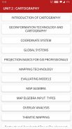
9. INTRODUÇÃO À CARTOGRAFIA
10. TECNOLOGIA DE GEOINFORMAÇÃO E CARTOGRAFIA
11. SISTEMA DE COORDENADAS
12. SISTEMAS GLOBAIS
13. FUNDAMENTOS DE PROJEÇÃO PARA PROFISSIONAIS DE SIG
14. ESCALA DO MAPA
15. PROJEÇÃO DE MAPA
16. TRANSFORMAÇÃO GEOMÉTRICA
17. DADOS VETORIAIS E RASTER
18. FENÔMENO SAPATIAL DE SIG
19. FUNÇÃO DE DADOS ESPACIAIS
20. TECNOLOGIAS DE COLETA DE DADOS
21. DETECÇÃO REMOTA
22. LEVANTAMENTO DO TERRENO
23. O Papel e a Natureza dos Modelos Ambientais
24. CONTEXTO DA MODELAGEM AMBIENTAL
25. RESUMO DO DESENVOLVIMENTO DO MODELO
26. MODELOS DE APLICAÇÃO
27. MODELAGEM DE TERRENOS
28. MODELAGEM DE TOPOGRAFIA
29. TIPOLOGIA DE MODELOS
30. ABORDAGENS DE MODELAGEM
31. REPRESENTAÇÃO E COMPUTAÇÃO DA DINÂMICA GEOGRÁFICA
32. MODELAGEM TEMPORAL
33. SIG TEMPORAL
34. CONCEITOS DE BANCO DE DADOS
35. PROJETO DO BANCO DE DADOS
36. TÉCNICAS DE ENTRADA DE DADOS
37. CODIFICAÇÃO DE DADOS
38. SISTEMA DE POSICIONAMENTO GLOBAL (GPS)
39. COMPARAÇÃO DE CODIFICAÇÃO E DECODIFICAÇÃO
40. LAYOUTS DE MAPAS
41. ELEMENTOS DE LAYOUT DE MAPA
42. PREENCHIMENTO DE MAPAS E SEQUÊNCIAS
43. TECNOLOGIAS DE SEQUENCIAMENTO
44. TECNOLOGIA DE MAPEAMENTO
45. MODELOS DE AVALIAÇÃO
46. MAPA DE ÁLGEBRA
47. TIPOS DE ENTRADA DE MAPA ELGEBRA
48. ANÁLISE DE SOBREPOSIÇÃO
49. SOBREPOSIÇÃO DE VECRTOR E RASTER
50. MODELAGEM DE TARAIN
51. INTERPOLAÇÃO ESPACIAL
52. FUNÇÃO DE TRANSFERÊNCIA
53. SIG E REDES NEURAIS ARTIFICIAIS
54. REDES
55. SIG E ANÁLISE DE REDE
56. APLICAÇÕES DE RECURSOS HÍDRICOS DE SIG
57. MODELAGEM HIDROLÓGICA
58. SIG E SOCIEDADE
59. SIG E TRANSPORTE
60. AVALIAÇÃO DE CARACTERÍSTICAS GEOTÉCNICAS BASEADA EM SIG
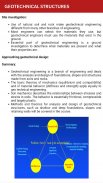
61. ESTRUTURAS GEOTÉCNICAS
62. GERAÇÃO DE DADOS ESPACIAIS EM SIG
63. MAPEAMENTO DA WEB
64. IMPORTÂNCIA DO DESIGN BASEADO NA WEB
65. ANÁLISE DE IMPACTO AMBIENTAL
66. SERVIÇO DE MAPA
67. ESTABELECIMENTO E DESENVOLVIMENTO DE SISTEMAS DE MONITORAMENTO EFA
68. SIG NA GESTÃO DE UTILITÁRIOS
69. MAPEAMENTO TEMTICO
70. Desenvolvimento de Energia Reestruturado-Acelerado e Reformas Programadas
71. GIS NA GESTÃO DE UTILITÁRIOS
72. MAPEAMENTO TEMTICO
73. Desenvolvimento de Energia Reestruturado-Acelerado e Reformas Programadas
74. FOTOGRAMETRIA
75. MAPEAMENTO MÓVEL
Todos os tópicos não estão listados devido a limitações de caracteres.
Recursos :
* Capítulo sábio Tópicos completos
* Layout de interface de usuário avançado
* Modo de leitura confortável
* Tópicos importantes do exame
* Interface de usuário muito simples
* Cobrir a maioria dos tópicos
* Um clique para obter todos os livros relacionados
* Conteúdo otimizado para celular
* Imagens otimizadas para celular
Cada tópico é completo com diagramas, equações e outras formas de representações gráficas para melhor aprendizado e compreensão rápida.
Este aplicativo será útil para referência rápida. A revisão de todos os conceitos pode ser concluída dentro de várias horas usando este aplicativo.
Em vez de nos dar uma classificação mais baixa, envie-nos suas dúvidas, problemas e nos dê uma avaliação e sugestão valiosas para que possamos considerá-la para futuras atualizações. Ficaremos felizes em resolvê-los para você.
Geographic Information System - Versão 11.0
(10-09-2024)Geographic Information System - Informação APK
Versão APK: 11.0Pacote: engg.hub.geoinformatics.systemÚltima Versão de Geographic Information System
Outras versões


 4.63
4.63


Apps na mesma categoria
 4.484.274.36
Também podes gostar...


